How accessible are playgrounds in the world’s cities? Where do children have safe, nearby places to play, move, and meet friends – and where are such spaces missing altogether?
A new web-based platform called Playscapes now makes it possible to explore these questions in detail. Developed by researchers at the World Playground Research Institute, the Swedish consultancy Spacescape, and web design firm On A Wednesday Afternoon (OAWA), Playscapes allows users to compare playground access across cities worldwide — from a global overview down to the neighborhood level.
It is currently a beta-version for testing, and we kindly invite everyone to explore the map and share their feedback in the built-in feedback function. Testing will continue until the end of November 2025.
Read on to learn more about how Playscapes works and what it can be used for.
How does it work?
When you open Playscapes, you’re greeted by an interactive world map that ranks cities according to the share of children with access to a playground.
You can filter the ranking by region, city size, or specific indicators such as the number of playgrounds per square kilometer or the percentage of children without access.
The dataset currently includes every city in the world with more than 50,000 inhabitants.
Zooming in on a specific city reveals detailed local statistics – including total population, number of children, number of playgrounds, and the share of children without access. Each city’s global and national ranking is also displayed, providing an instant sense of scale and comparison.
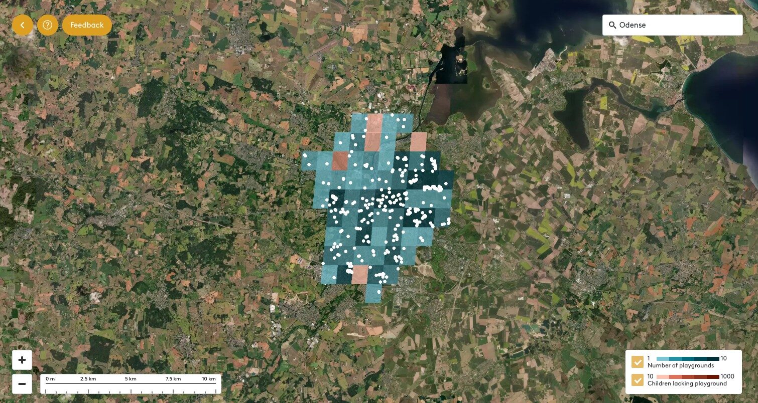
Ar an even finer level, users can explore playgrounds as individual dots on the map, overlaid with a 1×1 km grid that visualizes how access varies across different parts of the city. Clicking on a grid cell reveals the number of playgrounds – and how children have, or lack, access within that specific area.
What can Playscapes help with?
Playscapes is designed to be both intuitive and interactive. Users can zoom, pan, and toggle data layers on and off to explore playground access at different levels of detail. The platform functions simultaneously as a global benchmarking tool and a local analytical resource. This makes Playscapes a valuable tool for planners, researchers, and communities alike.
For urban planners and policymakers, Playscapes offers a way to identify underserved neighborhoods, monitor progress towards child-friendly city goals, and integrate play data into master plans, green infrastructure strategies, or public space programs.
For those involved in park management or playground development, Playscapes can help guide site selection, support funding proposals, and help evaluate how play spaces are distributed across the city.
Community groups and NGOs can also benefit. By visualizing where playground access is limited, Playscapes supports advocacy, inspire temporary interventions such as pop-up playgrounds, and strengthen participatory planning with residents.
Meanwhile, Researchers and educators can use Playscapes to study patterns of access, compare cities, or teach concepts related to spatial equity, urban health, and open data.
At the same time, the platform reveals data gaps, encouraging municipalities to improve their open datasets – and over time, strengthening the global knowledge base on public spaces and children’s well-being.
Facts about Playscapes
Behind Playscapes lies a robust methodology that combines open and internationally comparable datasets.
- Playground locations are extracted from OpenStreetMap
- Population and demographic data are drawn from Eurostat, the Global Human Settlement Layer (GHSL), and WorldPop.
Together, these sources make it possible to analyze children’s access to playgrounds across the world – at a 1 km² resolution. The combination of open data, spatial analysis, and interactive design makes Playscapes a unique digital tool for understanding and improving the everyday environments of children.
Access to play is about much more than recreation. It is about health, equality, and quality of life — about how we design cities for those who have the least influence but have the greatest need for space.
With Playscapes, the world has an open, evidence-based, and globally comparable tool to see where play happens — and where it doesn’t.
Explore the map at playgroundresearch.org/playscapes